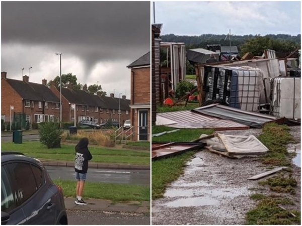
Exeat: Day 125/84: Tornado in Northampton ..really?
...or was it a funnel cloud?, That's seemingly the correct meteorological description. It formed at around 8pm July 25th. Although often referred to as tornados, the Met Office confirmed spinning, cone-shaped clouds only take the name tornados if they touch ground! But just a moment, this one did at Allotments from Duston to Kingsthorpe! Funnel clouds in the UK look like thin dangling bits of rope, hanging from the cloud above. But in hotspots such as Tornado Alley in the USA funnel clouds are often thicker and much more intense. They form when a rotating column of wind draws in cloud droplets making a region of intense low pressure visible. They are typically associated with the formation of cumulonimbus thunderclouds. When a funnel cloud makes contact with the ground and produce a tornado very strong winds can be expected in the immediate vicinity of the vortex potentially causing severe damage. We'd lived in The Alley in 1976 when I was teaching at University of Tulsa and the boys went to school; Avril became an expert on them! In a typical year, the UK sees around 30-35 tornadoes though it is very rare that are they strong enough to cause any significant damage.
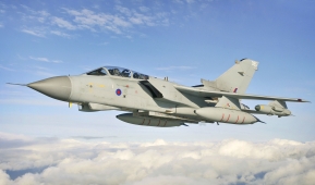
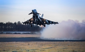
The RAF no longer flies its own Tornados … … the RAF's Tornado aircraft [below left] was in service for 40 years from the 1st Gulf War to Kosovo, Iraq, Syria and Afghanistan and withdrawn from service in April 2019. They were designed as a low level fighter/ bomber towards the end of the Cold War and the RAF had as many as 175 then. It was a joint Italian/ German/ British design. They've been replaced with Lightnings and Typhoons [below right] … which leads one to wonder: what's a typhoon c/p with a tornado? Indeed, what's a tornado c/p with any of three - typhoon, hurricane or cyclone? Where to start: Hurricanes and typhoons are the precisely the same weather phenomenon i.e. tropical cyclones. A tropical cyclone is a generic term used by meteorologists to describe a rotating, organized system of clouds and thunderstorms that originates over tropical or subtropical waters and has closed low-level circulation. The weakest tropical cyclones are simply called depressions or if intensified such that its maximum sustained winds reach 39 miles per hour it becomes a tropical storm. Once any tropical cyclone reaches maximum sustained winds of 74 miles per hour or higher it gets classified as a hurricane, typhoon or tropical cyclone, depending upon where the storm originates in the world. In the North Atlantic, central North Pacific, and eastern North Pacific, the term hurricane is used; in the Northwest Pacific it's called a typhoon. Meanwhile in the South Pacific and Indian Ocean [which course includes Queensland and Vanuatu of blessed memories!] cyclone is used regardless of the strength of the wind. Cyclone Uma, which hit Port Vila in February 1987, came a week after I'd left the island having established an MBA programme in partnership with the National Planning Office led by Augustine Garaea for Prime Minister Father Walter Lini. We were in Vila for our second with Julian for a Revans University/ IMCA Congregation … which went ahead with altered arrangements that saw Tom Bayer our colleague there awarded an Honorary Doctorate. N.B. The ingredients for tropical cyclones include a pre-existing weather disturbance, warm tropical oceans, moisture and relatively light winds. If the right conditions persist long enough they combine to produce the violent winds, large waves, torrential rains and floods we associate with them.
Definitions now: A cyclone is an atmospheric system characterized by the rapid inward circulation of air masses about a low-pressure centre usually accompanied by stormy often destructive weather. On landfall, because of insufficient supply of moisture and heat from the ocean and higher friction over the land than the sea surface tropical cyclones weaken. A tornado is a rotating column of air ranging in width from a few yards to more than a mile and whirling at destructively high speeds, usually accompanied by a funnel-shaped downward extension of a cumulonimbus cloud. It can run for just 10 seconds or so at a low velocity as in Northampton or at 300mph creating havoc along its extensive path. It occurs over land although a variant known as a waterspout can occur at sea and they sometimes move inland. Clearly they are NOT the same phenomena.
Published Date: July 25th 2020
|